Saturday, March 24, 2012

Mayon Volcano, Albay, Philippines

Mayon Volcano has been one of the main tourist attractions in Albay. Famous for its “Perfect Cone”, the Mayon Volcano is the Philippines’ most active volcano and the most popular tourist destination in the Bicol Region. With a height of 2,463 meters, it is the centerpiece of the Albay province, which is about 300 kilometers southeast of Manila, the capital of the Philippines.

Mayon Volcano has had 49, recorded eruptions, and continues to be active. Through the years, life and property has been claimed by this wonder of nature. Its first recorded eruption was in year 1616. Even without volcanic activity, the volcano continues to be dangerous for climbers, including the more experienced ones. Its steep slope make it difficult for climbing, thus it has claimed the lives of climbers in the recent years. Rock avalanches and landslides are common. If you want to climb the volcano, you’ll have to work your way through the forest, grasslands, and deserts. The safest way is to pass on the north western slope, but you will have to register at PHILVOCS to climb. Once you reach the summit, be wary of the dangerous fumes emitted by the Volcano. A gas mask in hand will be really useful.

Apart from climbing, you can go nature hiking and marvel at the many wonderful animals such as the parakeet, red jungle fowl, owl, fruit dove just to name a few. You can also do many activities such as hiking, camping, climbing, bird watching as well as photography.

The best time to visit the volcano is between the months of March and May. Do not visit the volcano during rainy season (Nov to Jan) because it is more dangerous. You can go there by land through the Quirino highway, which is about 553 kilometers away. The journey will take about 8 to 10 hours, and many buses depart every day from Manila to Legaspi.

Chocolate Hills, Bohol, Philippines

The Chocolate Hills are an unusual geological formation found in Bohol, in the Central Visayas region of the Philippines. There are at least 1,260 hills but there may be as many as 1,776 hills spread over an area of more than 50 square kilometres (20 sq mi). Depending on the season, the Chocolate Hills change in color, varying from green to chocolate brown. The Chocolate hills are the most famous tourist attraction in Bohol. The Chocolate hills were featured in the Philippine Tourism Authority’s list of Philippine tourist destinations and are the Philippines’ third National Geological Monument. Proposals to include the Chocolate hills in the UNESCO World Heritage Site list are currently being conducted.


The Chocolate Hills look like women’s dress, or giant mole hills, or something out of a child’s drawing. The unusual thing about it is that it is a natural phenomena! Geologists believe that the hills were formed from marine limestone on top of a clay layer. The Chocolate hills are uniform in shape, some standing from 30 to 50 meters high. They are usually covered with grass the year around, but turn brown during the dry season, thus the name. You can see the magnificent view by climbing 214 steps to an observation outpost above the hills.

You can get to the Chocolate Hills on your own or by joining a day tour. From Tagbilaran, go to the bus terminal in Dao, and take a bus to Carmen. Ask the bus driver to drop you off at Chocolate Hills, located 4 km before you reach Carmen. If you get lost you can always ask help from the locals who are very hospitable and friendly.
The Chocolate Hills is indeed one of the Philippines’ most amazing destinations. The Chocolate Hills Complex has: a hostel, swimming pool, restaurant, and an observation deck to view the amazing hills. You can also view the hills at Sagbayan Peak in the town of Sagbayan.

Tubbataha Reef Marine Park

The word tubbataha is a combination of two Samal words: tubba and taha, which together means "a long reef exposed at low tide". The Tubbataha Reef Marine Park, located in the Sulu Sea of the Philippines, is truly an example of nature’s beautiful creation one shouldn’t miss in their lifetime. It is one of the rare atoll reefs that provide life for a variety of marine species as well as magnificent corals. It is a marine sanctuary protected as Tubbataha Reef National Marine Park. The park is 33,200 hectares covering the North and South Reefs. The Northern part is also a nesting ground for marine turtles, as well as a variety of tropical birds.

Tubbataha Reef, although a great wonder on its own, is a newcomer to the world of tourism. Actions have been taken to make local Filipinos and the world aware of this special gift of nature. Many people travel across the globe to catch sight of this reef. Without immediate measures of preservation, the rare marine life found in Tubbataha Reef might not last for long.

There have been numerous attempts of illegal fishing in this area. The good news is there is an increase in awareness and protection. The area provides the main livelihood for many municipalities. But they now understand how important it is to preserve the marine life in this area. The reef is now a World Heritage site and is helping many local businesses develop new revenues from their livelihood. There is even a possibility of expanding the park. The management is continually making progress.

Tubbataha Reef is now a famous tourist destination. And the proceeds go to its preservation and development of the community. It is a perfect place for all you divers and nature lovers. It also makes for an idealistic sea adventure and a great way to get a close observation into the wonders of marine life. The locals are warm and hospitable. If you want a place to breathe the fresh air and gaze at the beauty of the sea teeming with marine life, Tubbataha Reef is the place to be. You would also be helping the conservation of nature.

Tuesday, March 20, 2012

Boracay, Philippines

Boracay is a tropical island located approximately 315km (200 miles) south of Manila and 2km off the northwest tip of the island of Panay in the Western Visayas region of the Philippines. It is one of the country's most popular tourist destinations. The island comprises the barangays of Manoc-Manoc, Balabag, and Yapak (3 of the 17 barangays which make up the municipality of Malay), and is under the administrative control of the Philippine Tourism Authority in coordination with the Provincial Government of Aklan.

Beaches
Perhaps the most popular beach here on the island is White Beach, which is due to its resplendent white sands and calm waters. Strong winds don't usually disturb both water and pristine sand on its side of the island, which makes it quite idyllic. This beach stretches to four kilometers in length and is lined by various hotels and resorts from one end to the other.

Of course, the other beaches in Boracay are also worth the trip and each one of them has something unique to offer to visitors and guests. After all, there is more to just pristine beauty that makes a beach part of the world's best. Some of the criteria that people ought to consider should include night attractions, dive spots, excellent cuisine, and top notch accommodations.

The Climate
The Boracay climate is pretty much the same as the typical climate you get in the Philippines. It enjoys a full summer season and also has a wet rainy season. The climate also dictates whether you get to spend more on room rates or not. The peak season includes the summer months in the Philippines. However, do take note that the months immediately preceding the summer is also part of the peak or high season as well.

So, this simply means that you should expect to find the room rates steeply high from January to May, which is the high to peak season. The rest of the months other than these are within the lean season or low season where there are fewer visitors on the island thus sparking lower demand and lower room rates. However, do take note that a good number of visitors also tend to come to Boracay starting in September.

Restaurants
On a related note, a stunning array of restaurants has also made their home on the island. A lot of these restaurants serve food from a variety of cuisines. It's like a culinary center right smack dab on the beach. You get to feast on different flavors renowned the world over. A huge number of these restaurants are located on Boat Station 2. Incidentally, this station is also where you'll find the majority of bars and night life places in Boracay.

Hotels and Resorts
If you think the number of restaurants, bars, and nightlife places here are quite a lot then guess again. There are in fact hundreds of hotels and resorts in Boracay. That is how popular this summer island is. You can just imagine how many people come here during peak season.

Since Boracay is such a huge tropical getaway in the Philippines, it is only a small wonder why there are so many hotels, inns, and resorts that have been put up. The hotels here range from small enterprises manned by a single owner or by a single family to a full blown luxurious establishment with international credentials to boot.

The hotels and resorts cater to backpackers as well as distinguishing luxury travelers. If you're on the island on a shoestring budget then you just have to know where to look to find the best deals. It's basically both a question of where and when you come over to have your time on the white sands.

Phi Phi Island, Thailand

The Phi Phi Islands are located in Thailand, between the large island of Phuket and the western Andaman Sea coast of the mainland. Phi Phi Don, the larger and principal of the two Phi Phi islands, is located at 7°44′00″N, 98°46′00″E. Both Phi Phi Don, and Phi Phi Leh, the smaller, are administratively part of Krabi province, most of which is on the mainland, and is located at 8°02′30″N, 98°48′39″E.

Ko Phi Phi Don (meaning "island" in the Thai language) is the largest island of the group, and is the only island with permanent inhabitants, although the beaches of the second largest island, Ko Phi Phi Lee (or "Ko Phi Phi Leh"), are visited by many people as well. There are no accommodation facilities on this island, but it is just a short boat ride from Ko Phi Phi Don. The rest of the islands in the group, including Bida Nok, Bida Noi, and Bamboo Island, are not much more than large limestone rocks jutting out of the sea.

Phi Phi Don was initially populated by Muslim fishermen during the late 1940s, and later became a coconut plantation. The Thai population of Phi Phi Don remains more than 80% Muslim.

Ko Phi Phi Leh was the backdrop for the 2000 movie The Beach. Phi Phi Leh also houses the 'Viking Cave', from which there is a thriving bird's nest soup industry. There was criticism during filming of 'The Beach' that the permission granted to the film company to physically alter the environment inside Phi Phi Islands National Park was illegal.

Following the release of The Beach, tourism on Phi Phi Don increased dramatically, and with it the population of the island. Many buildings were constructed without planning permission.

Cancun Beach, Mexico

Cancún is a coastal city in Mexico's easternmost state, Quintana Roo, on the Yucatán Peninsula best known as the Mexican Caribbean or at the northern section of the Mayan Riviera; however Cancun does not share a similar climate or topography to the Mediterranean.

It is the municipal seat of Benito Juárez municipality and a world-renowned tourist resort. The city center is located on the mainland which connects over the Nichupté and Bojórquez lagoons to a narrow "7" shaped island where the modern beachfront hotels are located. The island of Isla Mujeres is a nearby island located off the coast and is accessible by boat from Puerto Juarez or Punta Sam.

The older section of the city, known as "El Centro" follows the original master plan, consists of neighborhoods called "supermanzanas" (superblocks) that are formed by the intersections of the boulevards and traffic circles (roundabouts). This area is characterized by winding streets with cul-de-sacs that tend to keep out the main flow of traffic, including market places such Xel Ha. They usually have one or more parks, green spaces, paseos (pedestrian walkways) and various national historical monuments. Ave. Tulum is the main north-south artery (connecting downtown to the airport some 30km to south). Tulum is bisected by Ave. Coba (pronounced Koh bah). East of Ave. Tulum, Coba becomes Ave. Kukulcan which serves as the primary road that runs through the long "7" shaped hotel zone. Ave. Tulum is terminated on the north side by Ave. Paseo José López Portillo which connects to the main highway to Chichen Itza and Merida. Another major north-south road is Ave. Bonampak which runs roughly parallel to Ave. Tulum. The main ferry to Isla Mujeres is located off Bonampak.

The original master plan was repeatedly modified and, on the mainland, often ignored. To save on the cost of installing sewage systems and other public services, the design of much of the rest of the city reverted to the grid plan after Hurricane Gilbert (1988). The newest upper-middle-class residential areas reflect the original plan, but are much less intimate. Less expensive developments are comprised almost entirely of identical one- or two-story small row houses, sometimes built around interior plazas. Almost all buildings on the mainland are under four stories high.

Waikiki Beach, Honolulu, Hawaii

Waikiki is a neighborhood of Honolulu, in the City & County of Honolulu, on the south shore of the island of Oahu, Hawaii. Waikiki Beach is the shoreline fronting Waikiki and one of the best known beaches in the world.

The neighborhood extends from the Ala Wai Canal (a channel dug to drain former wetlands) on the west and north, to Diamond Head on the east. The name means spouting fresh water in Hawaiian for springs and streams that fed wetlands that once separated Waikiki from the interior. Waikiki has long been a place of relaxation. In particular, the area was a retreat for Hawaiian royalty in the 1800s.

Today the neighborhood and beach are considered the center of the tourist industry in Hawaii, with an abundance of both high-rise resort hotels (including the Hilton Hawaiian Village, the Halekulani hotel, the Hyatt Regency Waikiki, and the Sheraton Waikiki) and historic hotels dating back to the early 20th century (such as the Moana Surfrider Hotel and the Royal Hawaiian Hotel).

As seen in the picture, Waikiki Beach is noted for its magnificent view of Diamond Head. The frequently visited tourist beach, easily accessible by an alley next to the Royal Hawaiian Hotel, is actually fairly short, with half of it marked off for surfers. For some distance into the ocean the water is quite shallow, although there are numerous rocks on the bottom, so waders should watch where they put their feet. As with most ocean beaches the waves can have some force, particularly on windy days.

The beach has had its problems with erosion, leading to the construction of groins and beach replenishment projects. For example, in the 1920s and 1930s sand was obtained from Manhattan Beach, California, and transported via ship and barges to Waikiki.

Since 2001, there have been free movies on the beach. Many tourists from around the world can view a movie on an outdoor 30 foot screen. This particular free movie event in Waikiki is called "Sunset on the Beach". Sunset on the Beach typically shows movies of no higher than a PG rating. Recently, they showed Enchanted.

Copacabana Beach, Rio De Janeiro, Brazil

Copacabana is a borough located in the southern zone of the city Rio de Janeiro, famous for its 4 km beach.

The district was originally called Sacopenapã until the mid-18th century. It was renamed after the construction of a chapel holding a replica of the Virgin of Copacabana, the patron saint of Bolivia. It was incorporated into the city on July 6, 1892.

Copacabana begins at Princesa Isabel Avenue and ends at Posto Seis (lifeguard watchtower Six) near the Forte de Copacabana (Fort Copacabana). Beyond Copacabana, there is the small Arpoador beach, followed by the famous borough of Ipanema.

According to Riotur, the Tourism Secretariat of Rio de Janeiro, there are 63 hotels and 10 hostels in Copacabana.

Thursday, October 20, 2011

Bayonne Bridge

Bayonne Bridge is the fourth longest steel arch bridge in the world, and was the longest in the world at the time of its completion. It connects Bayonne , New Jersey with Staten island New York.

The bridge was designed by master bridge-builder Othmar Amman and the Architect Cass Gilbert. It was built by the Port of New York authority and opened on November 15, 1931. The primary purpose of the bridge was to allow vehicular traffic from Staten island to reach Manhattan via the Holland Tunnel.

Construction on the bridge began in 1928, and eventually cost $13 million. When it opened on November 15, 1931, it was the longest steel arch bridge in the world.Although it was deliberately built a few feet longer than the Sydney Harbour Bridge, David M. Dow, the Secretary for Australia in the United States, attended the dedication ceremony and noted that the bridge in Sydney was much larger and contained more than double the amount of steel. The same pair of golden shears used to cut the ribbon for the Bayonne Bridge was sent to Australia for the ribbon cutting of the Sydney Harbour Bridge

The presence of the Bayonne Bridge ultimately led to the discontinuation of the Bergen Point Ferry.

The supported roadway carries two lanes of traffic in each direction. The roadway deck could accommodate an expansion for either two traffic lanes or two light-rail lanes. A pedestrian walkway, cantilevered from the western side of the roadway, currently provides the only access by foot to Staten Island; at more or less normal walking speed, it takes approximately 25–30 minutes to walk from the street access on one side of the bridge to the street access on the other side. The Port Authority also permits bicycle traffic, however the sidewalk ends abruptly at descending stairs on the New Jersey side. Due to safety concerns, bicycle riders are required to walk their bicycles across the bridge.

Rio-Neteroi (President Costa e Silva Bridge)

Rio-Neteroi (President Costa e Silva Bridge) connects the cities of Rio de Janeiro and Niteroi in Brazil. It is currently the longest pre-stressed concrete bridge in the south hemisphere. From its completion in 1974 until 1985 it was the world’s second longest bridge in the world. Actual construction work begun in January 1969, and completed in March 1974.

The concept of its design dates back to 1875. In order to connect the two neighbouring towns, separated by the Guanabara Bay or an inland journey of more than 100 kilometers (62 mi), passing through the city of Mage. At the time it was intended to build a bridge and subsequently a tunnel.

In 1963 it has created a working group to study a project to build a road. On December 29, 1965, an executive committee was formed to take care of the final project of building a bridge.

The President Costa e Silva signed a decree on August 23 of 1968 Authorizing the project for the bridge, designed by Mario Andreazza Then Minister of Transport, under the management of whom the bridge was begun and completed.

Construction began symbolically on August 23, 1968, with the presence of Queen Elizabeth II of the United Kingdom and Prince Philip, Duke of Edinburgh, in their first and thus far only visit to Brazil, next to the minister Mario Andreazza. Actual work began in January, 1969, and it opened on March 4, 1974.

Its official name is the President Costa e Silva Bridge, in honor of the Brazilian President, Artur da Costa e Silva, who ordered its construction. "Rio-Niterói" started as a descriptive nickname that soon became better known than the official name. Today, hardly anyone refers to it by its official name.

The bridge was constructed by a pool of Brazilian construction firms. It is 13,290 m (8.25 mi) long – 8,836 m (5.49 miles) over water and the bridge's central span is 72 m (236.22 ft) high in order to allow the passage of hundreds of ships entering and leaving the bay every month. It carries140,000 vehicles daily, which pay a toll only when entering Niterói of 4.30 Brazilian real (as of August 2010), about US$2.45 or €1.95. It has 18 access points and eight overpasses.

Officially it is part of federal highway BR-101. Since June 1, 1995, it has been under the management of Ponte S.A., under a 20-year concession.

In the 2011 film, Fast Five, the Rio Niterio was featured in the film. The Puerto Rican bridge, Teodoro Moscoso, doubled for the bridge during the last moments of the film. Gal Gadot rode over this bridge on a bike in fast five.

Vasco da Gama Bridge

Vasco da Gama Bridge is a cable-stayed bridge flanked by viaducts and roads that spans over the Tagus River near Lisbon, capital of Portugal. It is the longest bridge in Europe with a total length of 17.2 km or 10.7 miles.

Bridge sections 
  • North access roads
  • North viaduct - 488 m (1,601 ft)
  • Expo viaduct - 672 m (2,205 ft); 12 sections
  • Main bridge - main span: 420 m (1,378 ft); side spans: 203 m (666 ft) each (total length: 829 m/2,720 ft); cement pillars: 150 m (492 ft)-high; free height for navigation in high tides: 45 m (148 ft);
  • Central viaduct - 6.351 m (20.84 ft); 80 pre-fabricated sections 78 m (256 ft)-long; 81 pillars up to 95 m (312 ft)-deep; height from 14 m (46 ft) to 30 m (98 ft)
  • South viaduct - 3.825 m (12.55 ft); 45 m (148 ft) sections; 84 sections; 85 pillars
  • South access roads - 3.895 m (12.78 ft); includes the toll plaza (18 gates) and two service areas
Construction and cost 
The project was split in four parts, each one built by a different company, and supervised by an independent consortium. There were up to 3,300 workers simultaneously on the project, which took 18 months of preparation and another 18 months of construction.

The bridge has a life expectancy of 120 years, having been designed to withstand wind speeds of 250 km/h (155 mph) and hold up to an earthquake 4.5 times stronger than the historical 1755 Lisbon earthquake (estimated at 8.7 on the Richter scale). The deepest foundation piles, up to 2.2 m (7.2 ft) in diameter, were driven down to 95 m (312 ft) under mean sea level. Due to the bridge's length, it was necessary to take the Earth's curvature into account to site the piers correctly, otherwise a deviation of 80 cm (31 in) would be apparent at either end of the bridge. Environmental pressure throughout the project resulted in the left-bank viaducts being extended inland to preserve the marshes underneath, as well as the lamp posts throughout the bridge being tilted inwards so as not to cast light on the river below.

The cost of the bridge came at zero to the State, as it was built in the BOT (build-operate-transfer) system by Lusoponte, a private consortium which got a 40-year concession on the tolls of both Lisbon bridges. Lusoponte's capital is 50.4% from Portuguese companies, 24.8% French and 24.8% British.

As of 2009, the toll is €2.40 per passenger car (up to €10.80 per truck) northbound (into Lisbon). There is no toll for southbound traffic.

Seven Mile Bridge

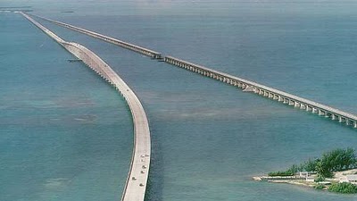
Seven Mile Bridge is a famous bridge in the Florida Keys, in Monroe County, Florida, United States. It connects Knight's Key (part of the city of Marathon, Florida) in the Middle Keys to Little Duck Key in the Lower Keys. Among the longest bridges in existence when it was built, it is one of the many bridges on US 1 in the Keys, where the road is called the Overseas Highway.

There are two bridges in this location. The older bridge, originally known as the Knights Key-Pigeon Key-Moser Channel-Pacet Channel Bridge, was constructed from 1909-1912 under the direction of Henry Flagler as part of the Florida East Coast Railway's Key West Extension, also known as the Overseas Railroad.

This bridge was badly damaged by the Labor Day Hurricane of 1935, and subsequently refurbished by the United States Federal Government as an automobile highway bridge. It had a swing span that opened to allow passage of boat traffic, near where the bridge crosses Pigeon Key, a small island where a work camp for Flagler's railroad was located. Hurricane Donna in 1960 caused further damage.

The current road bridge was constructed from 1978 to 1982. The vast majority of the original bridge still exists, used as fishing piers and access to Pigeon Key, but the swing span over the Moser Channel of the Intracoastal Waterway has been removed.

he new bridge is a box-girder structure built from precast, prestressed concrete sections, comprising 440 spans. Near the center, the bridge rises in an arc to provide 65-foot (20 m)-high clearance for boat passage. The remainder of the bridge is considerably closer to the water surface. The new bridge does not cross Pigeon Key.

The total length of the new bridge is actually 35,862 ft (10,931 m) or 6.79 miles (10.93 km), and is shorter than the original. Each April the bridge is closed for approximately 2.5 hours on a Saturday and a "fun run," known as the Seven Mile Bridge Run, of 1,500 runners is held commemorating the Florida Keys bridge rebuilding project. The event began in 1982 to commemorate the completion of a federally funded bridge building program that replaced spans that oil tycoon Henry Flagler constructed in the early 1900s to serve as a foundation for his Overseas Railroad.

The Seven Mile Bridge was engineered by Figg & Muller Engineers. The structure was completed six months ahead of schedule and has earned eight awards, including an Exceptional Award for Cost Savings Innovation from the Federal Highway Administration.

Confederation Bridge

Confederation Bridge is 12.9 km or 8 mile long bridge opened on 31 May 1997. It is a bridge spanning the Abegweit Passage of Northumberland Starit, linking Prince Edward Island with mainland New Brunkswick, Canada.

Its construction took place from all the fall of 1993 to the spring of 1997, costing $1.3 billion and completed on December 1997.

The bridge is a two-lane highway toll bridge that carries the Trans-Canada Highway between Borden-Carleton, Prince Edward Island (at Route 1) and Cape Jourimain, New Brunswick (at Route 16).

It is a multi-span post-tensioned concrete box girder structure. Most of the curved bridge is 40 metres (131 ft) above water, and it contains a 60 m (197 ft) high navigation span to permit ship traffic. The bridge rests on 62 piers, of which the 44 main piers are 250 m (820 ft) apart. The bridge is 11 m (36 ft) wide.

The speed limit on the bridge is 80 kilometres per hour (50 mph). It takes about 10 minutes to cross the bridge.

Tolls are paid only when exiting Prince Edward Island; the toll rate as of July 2011 is C$43.25 for a two-axle automobile and C$7.00 for each additional axle. Motorcycles are charged C$17.25. Currently it is, by far, the most expensive toll bridge in North America.[citation needed]

While pedestrians and cyclists are not permitted to cross, a shuttle service is available. The shuttle service was free of charge prior to 2006, but the shuttle service has charged C$4.00 per pedestrian or C$8.00 per cyclist since January 1, 2006. The fare is only applied when leaving Prince Edward Island (i.e., westbound).

The other major Northumberland Strait crossing, Wood Islands Ferry from Wood Islands, Prince Edward Island to Caribou, Nova Scotia, currently only assesses its C$65.00 per car fare when exiting Prince Edward Island as well. Therefore, travellers entering the island on the bridge and exiting on the ferry or vice versa only need pay for one of the links.

Donghai Bridge (East Sea Grand Bridge)

Donghai Bridge, sometimes called East Sea Grand Bridge, is the first sea-crossing bridge in the China. It was the longest cross-sea bridge in the world until Hangzhou Bay Bridge opened on 1 May 2008. This 20-mile, six-lane bridge was opened for the public in Dec, 2005. Stretching across the East China Sea, the graceful cable-stay structure connects Shanghai to Yangshan Island, set to become China's first free-trade port (and the world's largest container port).

Although Donghai Bridge only held the title “the longest trans-oceanic bridge in the world” for a few years before the Hangzhou Bay Bridge was finished in 2008, Donghai Bridge is still proud of being the first sea-crossing bridge in China.

Structure
Donghai Bridge is designed into an S-shaped because of the safety issue. It starts at Shanghai Luchao Harbor, and crosses the open sea to the Phase I junction of Xiaoyangshan Harbor. Aiming to prevent this bridge being damaged by the typhoons and high waves which are frequently attack this region, $1.2 billion was invested to this project.

China Donghai Bridge is 32.5 kilometers long with three sections. The part on the land is 3.7 kilometers, the part between Luchaogang Dam to Dawugui Island is about 25.3 kilometers, the part between Dawugui Island to Xiaoyangshan Island is 3.5 kilometer. The width of Dongshan Bridge is 31.5 meters. Dongshan Bridge gets a 100-year, service guaranteed with an 80km/h speed limit.

Significance
The completely Donghai Bridge improved the traffic situation in Shanghai. It provided a basic to quicken the paces of the Yangshan Harbor project and the construction of Shanghai international shipping center.

The project is characterized by its large scale, the severe environmental conditions, the high technical difficulties, and the short construction duration; therefore, the design of this bridge brought about a series of problems which were never faced before and required detailed analysis and study to solve. The designers worked out the plans and techniques for safe and efficient off-shore construction; as a successful result, the construction of the bridge took merely 40 months from June 2002 to October 2005.

King Fahd Causeway

King Fahd Causeway built to connect Saudi Arabia and Bahrain. It is a bridge combination connecting Khobar, Saudi Arabia, and the island nation of Bahrain.

In 1965, the desire to construct the causeway began to take form officially when Shaikh Khalifah ibn Sulman Al Khalifah of Bahrain paid a courtesy visit to King Faisal and the king expressed his wish to have the causeway constructed. In 1968, both countries formed a joint committee to assess the financial undertaking required for the task. As a result the World Bank was requested by the committee to contribute their assistance in methods of implementation of the mammoth-sized project. This required taking into account the environmental and geographical aspects of the Saudi-Bahrain region. In the summer of 1973, King Faisal, in a meeting which included Amir Shaikh Isa bin Salman Al Khalifa as well as the then prince, Fahd bin Abdul Aziz and Shaikh Khalifa bin Salman Al Khalifa, suggested that committee overlook the economic and financial aspects of the project and concentrate on the actual construction of the causeway. 

In 1975, the World Bank submitted its study and advice after seeking assistance from specialist international expertise in studying the geographic, environmental factors and maritime currents. In the spring of 1976, during a visit by King Khalid bin Abdul Aziz to Shaikh Isa bin Salman Al Khalifa, the two monarchs agreed to set up a ministerial committee from the two countries to work on the implementation of the project.

On 8 July 1981, Mohammed Aba Al-Khail, the then minister for Finance and National Economy of Saudi Arabia and Yousuf Ahmed Al-Shirawi, the then minister of Industrial Development in Bahrain signed an agreement to start construction on the maritime causeway. On November 11, 1982, King Fahd bin Abdul Aziz and Shaikh Isa bin Salman Al Khalifa unveiled the curtain off the Memorial Panel in an official ceremony attended by the leaders of the GCC states for work on the project to commence. On 11 April 1985, Shaikh Khalifa bin Salman Al Khalifa pushed the button required to install the final part of the box bridges thereby finally linking Saudi mainland with the island of Bahrain.

On 26 November 1986, the causeway was officially inaugurated by King Fahd bin Abdul Aziz and Shaikh Isa bin Salman as the King Fahd Causeway.

As of 2008, it is estimated that number of vehicles using the causeway is about 45,000 on weekdays and up to 60,000 on weekends. The total number of travelers across the causeway from both countries in the year 2008 was 17.7 million passengers, or an average of 48,600 passengers per day

San Mateo – Hayward Bridge

San Mateo – Hayward Bridge (commonly called the San Mateo Bridge) is a bridge crossing California's San Francisco Bay in the United States, linking the San Francisco Peninsula with the East Bay. More specifically, the bridge's western end is in Foster City, the most recent urban addition to the eastern edge of San Mateo. The eastern end of the bridge is in Hayward. It is the longest bridge in the San Francisco Bay Area and the 25th longest in the world by length. The bridge is owned by the state of California, and is maintained by Caltrans, the state highway agency.

The bridge is part of State Route 92, whose western terminus is at the town of Half Moon Bay on the Pacific coast. Its principal function is to link Interstate 880 in the East Bay with U.S. Route 101 on the Peninsula. It is roughly parallel to and lies between the San Francisco – Oakland Bay Bridge and the Dumbarton Bridge, and is sometimes used by commuters to avoid traffic delays due to emergencies on those bridges.

The original bridge, known as the San Francisco Bay Toll-Bridge, was built in 1929, and upon completion was the longest bridge in the world. The original bridge was mostly a two-lane causeway with a 300-foot (91 m) vertical lift span over the main shipping channel. The bridge originally had pole lights along the entire stretch, which were later abandoned except over the vertical lift span. It was subsequently replaced with a modern span in 1967. The total length of the bridge is 7.0 miles (11.3 km). The 1.9 miles (3.1 km) highrise section, forming the western end of the bridge, is composed of multiple steel girder spans. The eastern trestle portion accounts for the remaining 5.1 mi (8.2 km) of the overall length. The shipping channel beneath the highrise is 750 feet (229 m) wide with a vertical clearance of 135 feet (41 m). The bridge recently underwent an extensive seismic retrofitting to protect against earthquake damage. The bridge carries about 93,000 cars and other vehicles on a typical day.

The highrise section was initially built with six lanes and the eastern causeway with four lanes (two in each direction). The causeway section was a perennial traffic bottleneck until it was expanded to six lanes in 2004, along with much needed improvements in its connections with Interstate 880 in Hayward.

Bus service over the bridge is provided by AC Transit's Line M transbay service.

High-voltage power lines built by PG&E parallel the bridge all the way across the bay. They provide power to the Peninsula and San Francisco.

Chesapeake Bay Bridge

Chesapeake Bay Bridge is also known as the Bay Bridge. It was built in 1952 and named the William Preston Lane, Jr. Memorial Bridge after William Preston Lane, Jr. who, as governor of Maryland, implemented its construction.

It is a major dual-span bridge in the state of Maryland; spanning the Chesapeake Bay, built to connect the state’s Eastern and Western Shore regions. At 7 km in length, the original span was the world’s longest continuous over-water steel structure when it opened in 1952.

The bridge is part of U.S. Routes 50 and 301, and serves as a vital link in both routes. As part of U.S. Route 50, it connects the Baltimore-Washington Metropolitan Area with Ocean City, Maryland and other coastal tourist destinations. As part of U.S. Route 301, it serves as part of an alternate route for Interstate 95 travelers between northern Delaware and the Washington, D.C. area. Because of this linkage, the bridge is heavily traveled and has become known as a point of traffic congestion, particularly during peak hours and summer months.

Penang Bridge

Penang Bridge is a dual-carriageway toll bridge that connects Gelugor on the island of Penang and Seberang Prai on the mainland of Malaysia on the Malay Peninsula. The bridge is also linked to the Norht-South Expressway in Prai and Jelutong Expressway inPenang . The total length of the bridge is 8.4 miles, making it among the longest bridges in the world, the longest bridge in the country as well as a national landmark. PLUS Expressway Berhad is the concession holder which manages it. 

The Penang Bridge is no doubt one of the many architecture wonders of Penang. Ranks as the longest bridge in Asia and 5th largest in the world, the iconic bridge that took 5 years to complete was the beloved bridge for every Penangtes. It marks the new milestone that brings Penang closer to the world attention. 

With the price tag of $629 million and revised for few more times up to $850 million, Penang Bridge are projected to transport up to 50,000 commuter in and out of the island. About $525 million was for the bridge itself, $180 million for the interchanges on the Prai side, and more than $30 million for land reclamation, compensation for landowner and others. The bridge has an overall length of 13.5km, four towers in mid span his 101.5 metres tall, and is 33 metres above water. The total length of piling for the bridge is 648km, equal to the distance from Butterworth to Johor Bahru. It can withstand earthquake up to 7.5 on the Richter scale. 

More than 2300 people were involved in the construction, including about 800 South Koreans from the main contractor, Hyundai Engineering and Construction Co. Ltd. Sadly to say, twenty workers loss their life during the construction. Between 1981 and 1985, Penangtes waited eagerly as the bridge construction took shape over the horizon.

Petronas Twin Towers (Menara Berkembar Petronas)

Petronas Twin Towers are tied for the spot of fourth tallest building in the World. These towers, located in Kuala Lumpur, Malaysia, are about 1,483 feet (452 meters) in height an each have 88 floors. These Twin Towers are connected by a sky-bridge between the 41st and 42nd floors. This bridge is the highest two story bridge in the world and is about 170 meters above the ground and weighs about 750 tons. This bridge is open to all visitors who use the lower level for travel and view, while the people in the apartments use the upper portion of the bridge. It should be noted that free passes that allow visitors up, though are limited and are given out on a first come, first serve basis.

The towers feature a skybridge between the two towers on 41st and 42nd floors, which is the highest 2-story bridge in the world. It is not attached to the main structure, but is instead designed to slide in and out of the towers to prevent it from breaking, as the towers sway several feet[specify] in towards and away from each other during high winds. It also provides some structural support to the towers in these occasions. The bridge is 170 m (558 ft) above the ground and 58 m (190 ft) long, weighing 750 tons. The same floor is also known as the podium, since visitors desiring to go to higher levels have to change elevators here. The skybridge is open to all visitors, but tickets are limited to about 1000 people per day, and must be obtained on a first-come, first-served basis. Initially, the visit was free but in 2010, the tickets started being sold by Petronas. Visitors can choose to opt for package one which is just a visit to the skybridge or go for package two to go to the skybridge and all the way to level 86. Visitors are only allowed on the 41st floor as the 42nd floor can only be used by the tenants of the building.

The skybridge also acts as a safety device, so that in the event of a fire or other emergency in one tower, tenants can evacuate by crossing the skybridge to the other tower.The total evacuation triggered by a bomb hoax on September 12, 2001 (the day after the September 11 attacks destroyed the twin towers of the World Trade Center in New York City) showed that the bridge would not be useful if both towers need to be emptied simultaneously, as the capacity of the staircases was insufficient for such an event.Plans thus call for the lifts to be used if both towers need to be evacuated, and a successful drill following the revised plan was conducted in 2005.

The Petronas Towers were the tallest buildings in the world for six years, until Taipei 101 was completed in 2004. The height of the towers is measured to the top of their structural components such as spires, but do not include antennas. Spires are considered actual integral parts of the architectural design of buildings, to which changes would substantially change the appearance and design of the building, whereas antennas may be added or removed without such consequences. The Petronas Towers still remain the tallest twin buildings in the world

CITIC Plaza

CITIC Plaza is the world’s tallest concrete building. It stands at about 1,283 feet (391 meters) tall and is located in the Republic of China. This and the other tall buildings that are taking over in Guangzhou, is a sign of the cities increasing wealth and ever-rising importance.

Located in the growing and expanding Tianhe District, it is part of a complex of the same name which also consists of two 38-story residential buildings. Its proximity includes a new train station which serves the extremely busy Guangzhou-Shenzhen and Guangzhou-Hong Kong railways. A new metro station, and the Tianhe Sports Center, where the 6th National Games was held and parts of the upcoming Asian Games 2010 will be held. It is on the same Axis as two new building developments in Guangzhou, the first being the East and West Towers in Zhujiang New City and the Pearl Observation tower. It is surrounded by other tall buildings and is a symbol of Guangzhou's growing wealth and importance.