Showing posts with label World Longest Bridges. Show all posts

Thursday, October 20, 2011

Bayonne Bridge

Bayonne Bridge is the fourth longest steel arch bridge in the world, and was the longest in the world at the time of its completion. It connects Bayonne , New Jersey with Staten island New York.

The bridge was designed by master bridge-builder Othmar Amman and the Architect Cass Gilbert. It was built by the Port of New York authority and opened on November 15, 1931. The primary purpose of the bridge was to allow vehicular traffic from Staten island to reach Manhattan via the Holland Tunnel.

Construction on the bridge began in 1928, and eventually cost $13 million. When it opened on November 15, 1931, it was the longest steel arch bridge in the world.Although it was deliberately built a few feet longer than the Sydney Harbour Bridge, David M. Dow, the Secretary for Australia in the United States, attended the dedication ceremony and noted that the bridge in Sydney was much larger and contained more than double the amount of steel. The same pair of golden shears used to cut the ribbon for the Bayonne Bridge was sent to Australia for the ribbon cutting of the Sydney Harbour Bridge

The presence of the Bayonne Bridge ultimately led to the discontinuation of the Bergen Point Ferry.

The supported roadway carries two lanes of traffic in each direction. The roadway deck could accommodate an expansion for either two traffic lanes or two light-rail lanes. A pedestrian walkway, cantilevered from the western side of the roadway, currently provides the only access by foot to Staten Island; at more or less normal walking speed, it takes approximately 25–30 minutes to walk from the street access on one side of the bridge to the street access on the other side. The Port Authority also permits bicycle traffic, however the sidewalk ends abruptly at descending stairs on the New Jersey side. Due to safety concerns, bicycle riders are required to walk their bicycles across the bridge.

Rio-Neteroi (President Costa e Silva Bridge)

Rio-Neteroi (President Costa e Silva Bridge) connects the cities of Rio de Janeiro and Niteroi in Brazil. It is currently the longest pre-stressed concrete bridge in the south hemisphere. From its completion in 1974 until 1985 it was the world’s second longest bridge in the world. Actual construction work begun in January 1969, and completed in March 1974.

The concept of its design dates back to 1875. In order to connect the two neighbouring towns, separated by the Guanabara Bay or an inland journey of more than 100 kilometers (62 mi), passing through the city of Mage. At the time it was intended to build a bridge and subsequently a tunnel.

In 1963 it has created a working group to study a project to build a road. On December 29, 1965, an executive committee was formed to take care of the final project of building a bridge.

The President Costa e Silva signed a decree on August 23 of 1968 Authorizing the project for the bridge, designed by Mario Andreazza Then Minister of Transport, under the management of whom the bridge was begun and completed.

Construction began symbolically on August 23, 1968, with the presence of Queen Elizabeth II of the United Kingdom and Prince Philip, Duke of Edinburgh, in their first and thus far only visit to Brazil, next to the minister Mario Andreazza. Actual work began in January, 1969, and it opened on March 4, 1974.

Its official name is the President Costa e Silva Bridge, in honor of the Brazilian President, Artur da Costa e Silva, who ordered its construction. "Rio-NiterĂ³i" started as a descriptive nickname that soon became better known than the official name. Today, hardly anyone refers to it by its official name.

The bridge was constructed by a pool of Brazilian construction firms. It is 13,290 m (8.25 mi) long – 8,836 m (5.49 miles) over water and the bridge's central span is 72 m (236.22 ft) high in order to allow the passage of hundreds of ships entering and leaving the bay every month. It carries140,000 vehicles daily, which pay a toll only when entering NiterĂ³i of 4.30 Brazilian real (as of August 2010), about US$2.45 or €1.95. It has 18 access points and eight overpasses.

Officially it is part of federal highway BR-101. Since June 1, 1995, it has been under the management of Ponte S.A., under a 20-year concession.

In the 2011 film, Fast Five, the Rio Niterio was featured in the film. The Puerto Rican bridge, Teodoro Moscoso, doubled for the bridge during the last moments of the film. Gal Gadot rode over this bridge on a bike in fast five.

Vasco da Gama Bridge

Vasco da Gama Bridge is a cable-stayed bridge flanked by viaducts and roads that spans over the Tagus River near Lisbon, capital of Portugal. It is the longest bridge in Europe with a total length of 17.2 km or 10.7 miles.

Bridge sections 
  • North access roads
  • North viaduct - 488 m (1,601 ft)
  • Expo viaduct - 672 m (2,205 ft); 12 sections
  • Main bridge - main span: 420 m (1,378 ft); side spans: 203 m (666 ft) each (total length: 829 m/2,720 ft); cement pillars: 150 m (492 ft)-high; free height for navigation in high tides: 45 m (148 ft);
  • Central viaduct - 6.351 m (20.84 ft); 80 pre-fabricated sections 78 m (256 ft)-long; 81 pillars up to 95 m (312 ft)-deep; height from 14 m (46 ft) to 30 m (98 ft)
  • South viaduct - 3.825 m (12.55 ft); 45 m (148 ft) sections; 84 sections; 85 pillars
  • South access roads - 3.895 m (12.78 ft); includes the toll plaza (18 gates) and two service areas
Construction and cost 
The project was split in four parts, each one built by a different company, and supervised by an independent consortium. There were up to 3,300 workers simultaneously on the project, which took 18 months of preparation and another 18 months of construction.

The bridge has a life expectancy of 120 years, having been designed to withstand wind speeds of 250 km/h (155 mph) and hold up to an earthquake 4.5 times stronger than the historical 1755 Lisbon earthquake (estimated at 8.7 on the Richter scale). The deepest foundation piles, up to 2.2 m (7.2 ft) in diameter, were driven down to 95 m (312 ft) under mean sea level. Due to the bridge's length, it was necessary to take the Earth's curvature into account to site the piers correctly, otherwise a deviation of 80 cm (31 in) would be apparent at either end of the bridge. Environmental pressure throughout the project resulted in the left-bank viaducts being extended inland to preserve the marshes underneath, as well as the lamp posts throughout the bridge being tilted inwards so as not to cast light on the river below.

The cost of the bridge came at zero to the State, as it was built in the BOT (build-operate-transfer) system by Lusoponte, a private consortium which got a 40-year concession on the tolls of both Lisbon bridges. Lusoponte's capital is 50.4% from Portuguese companies, 24.8% French and 24.8% British.

As of 2009, the toll is €2.40 per passenger car (up to €10.80 per truck) northbound (into Lisbon). There is no toll for southbound traffic.

Seven Mile Bridge

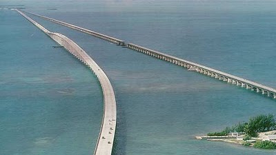
Seven Mile Bridge is a famous bridge in the Florida Keys, in Monroe County, Florida, United States. It connects Knight's Key (part of the city of Marathon, Florida) in the Middle Keys to Little Duck Key in the Lower Keys. Among the longest bridges in existence when it was built, it is one of the many bridges on US 1 in the Keys, where the road is called the Overseas Highway.

There are two bridges in this location. The older bridge, originally known as the Knights Key-Pigeon Key-Moser Channel-Pacet Channel Bridge, was constructed from 1909-1912 under the direction of Henry Flagler as part of the Florida East Coast Railway's Key West Extension, also known as the Overseas Railroad.

This bridge was badly damaged by the Labor Day Hurricane of 1935, and subsequently refurbished by the United States Federal Government as an automobile highway bridge. It had a swing span that opened to allow passage of boat traffic, near where the bridge crosses Pigeon Key, a small island where a work camp for Flagler's railroad was located. Hurricane Donna in 1960 caused further damage.

The current road bridge was constructed from 1978 to 1982. The vast majority of the original bridge still exists, used as fishing piers and access to Pigeon Key, but the swing span over the Moser Channel of the Intracoastal Waterway has been removed.

he new bridge is a box-girder structure built from precast, prestressed concrete sections, comprising 440 spans. Near the center, the bridge rises in an arc to provide 65-foot (20 m)-high clearance for boat passage. The remainder of the bridge is considerably closer to the water surface. The new bridge does not cross Pigeon Key.

The total length of the new bridge is actually 35,862 ft (10,931 m) or 6.79 miles (10.93 km), and is shorter than the original. Each April the bridge is closed for approximately 2.5 hours on a Saturday and a "fun run," known as the Seven Mile Bridge Run, of 1,500 runners is held commemorating the Florida Keys bridge rebuilding project. The event began in 1982 to commemorate the completion of a federally funded bridge building program that replaced spans that oil tycoon Henry Flagler constructed in the early 1900s to serve as a foundation for his Overseas Railroad.

The Seven Mile Bridge was engineered by Figg & Muller Engineers. The structure was completed six months ahead of schedule and has earned eight awards, including an Exceptional Award for Cost Savings Innovation from the Federal Highway Administration.

Confederation Bridge

Confederation Bridge is 12.9 km or 8 mile long bridge opened on 31 May 1997. It is a bridge spanning the Abegweit Passage of Northumberland Starit, linking Prince Edward Island with mainland New Brunkswick, Canada.

Its construction took place from all the fall of 1993 to the spring of 1997, costing $1.3 billion and completed on December 1997.

The bridge is a two-lane highway toll bridge that carries the Trans-Canada Highway between Borden-Carleton, Prince Edward Island (at Route 1) and Cape Jourimain, New Brunswick (at Route 16).

It is a multi-span post-tensioned concrete box girder structure. Most of the curved bridge is 40 metres (131 ft) above water, and it contains a 60 m (197 ft) high navigation span to permit ship traffic. The bridge rests on 62 piers, of which the 44 main piers are 250 m (820 ft) apart. The bridge is 11 m (36 ft) wide.

The speed limit on the bridge is 80 kilometres per hour (50 mph). It takes about 10 minutes to cross the bridge.

Tolls are paid only when exiting Prince Edward Island; the toll rate as of July 2011 is C$43.25 for a two-axle automobile and C$7.00 for each additional axle. Motorcycles are charged C$17.25. Currently it is, by far, the most expensive toll bridge in North America.[citation needed]

While pedestrians and cyclists are not permitted to cross, a shuttle service is available. The shuttle service was free of charge prior to 2006, but the shuttle service has charged C$4.00 per pedestrian or C$8.00 per cyclist since January 1, 2006. The fare is only applied when leaving Prince Edward Island (i.e., westbound).

The other major Northumberland Strait crossing, Wood Islands Ferry from Wood Islands, Prince Edward Island to Caribou, Nova Scotia, currently only assesses its C$65.00 per car fare when exiting Prince Edward Island as well. Therefore, travellers entering the island on the bridge and exiting on the ferry or vice versa only need pay for one of the links.

Donghai Bridge (East Sea Grand Bridge)

Donghai Bridge, sometimes called East Sea Grand Bridge, is the first sea-crossing bridge in the China. It was the longest cross-sea bridge in the world until Hangzhou Bay Bridge opened on 1 May 2008. This 20-mile, six-lane bridge was opened for the public in Dec, 2005. Stretching across the East China Sea, the graceful cable-stay structure connects Shanghai to Yangshan Island, set to become China's first free-trade port (and the world's largest container port).

Although Donghai Bridge only held the title “the longest trans-oceanic bridge in the world” for a few years before the Hangzhou Bay Bridge was finished in 2008, Donghai Bridge is still proud of being the first sea-crossing bridge in China.

Structure
Donghai Bridge is designed into an S-shaped because of the safety issue. It starts at Shanghai Luchao Harbor, and crosses the open sea to the Phase I junction of Xiaoyangshan Harbor. Aiming to prevent this bridge being damaged by the typhoons and high waves which are frequently attack this region, $1.2 billion was invested to this project.

China Donghai Bridge is 32.5 kilometers long with three sections. The part on the land is 3.7 kilometers, the part between Luchaogang Dam to Dawugui Island is about 25.3 kilometers, the part between Dawugui Island to Xiaoyangshan Island is 3.5 kilometer. The width of Dongshan Bridge is 31.5 meters. Dongshan Bridge gets a 100-year, service guaranteed with an 80km/h speed limit.

Significance
The completely Donghai Bridge improved the traffic situation in Shanghai. It provided a basic to quicken the paces of the Yangshan Harbor project and the construction of Shanghai international shipping center.

The project is characterized by its large scale, the severe environmental conditions, the high technical difficulties, and the short construction duration; therefore, the design of this bridge brought about a series of problems which were never faced before and required detailed analysis and study to solve. The designers worked out the plans and techniques for safe and efficient off-shore construction; as a successful result, the construction of the bridge took merely 40 months from June 2002 to October 2005.

King Fahd Causeway

King Fahd Causeway built to connect Saudi Arabia and Bahrain. It is a bridge combination connecting Khobar, Saudi Arabia, and the island nation of Bahrain.

In 1965, the desire to construct the causeway began to take form officially when Shaikh Khalifah ibn Sulman Al Khalifah of Bahrain paid a courtesy visit to King Faisal and the king expressed his wish to have the causeway constructed. In 1968, both countries formed a joint committee to assess the financial undertaking required for the task. As a result the World Bank was requested by the committee to contribute their assistance in methods of implementation of the mammoth-sized project. This required taking into account the environmental and geographical aspects of the Saudi-Bahrain region. In the summer of 1973, King Faisal, in a meeting which included Amir Shaikh Isa bin Salman Al Khalifa as well as the then prince, Fahd bin Abdul Aziz and Shaikh Khalifa bin Salman Al Khalifa, suggested that committee overlook the economic and financial aspects of the project and concentrate on the actual construction of the causeway. 

In 1975, the World Bank submitted its study and advice after seeking assistance from specialist international expertise in studying the geographic, environmental factors and maritime currents. In the spring of 1976, during a visit by King Khalid bin Abdul Aziz to Shaikh Isa bin Salman Al Khalifa, the two monarchs agreed to set up a ministerial committee from the two countries to work on the implementation of the project.

On 8 July 1981, Mohammed Aba Al-Khail, the then minister for Finance and National Economy of Saudi Arabia and Yousuf Ahmed Al-Shirawi, the then minister of Industrial Development in Bahrain signed an agreement to start construction on the maritime causeway. On November 11, 1982, King Fahd bin Abdul Aziz and Shaikh Isa bin Salman Al Khalifa unveiled the curtain off the Memorial Panel in an official ceremony attended by the leaders of the GCC states for work on the project to commence. On 11 April 1985, Shaikh Khalifa bin Salman Al Khalifa pushed the button required to install the final part of the box bridges thereby finally linking Saudi mainland with the island of Bahrain.

On 26 November 1986, the causeway was officially inaugurated by King Fahd bin Abdul Aziz and Shaikh Isa bin Salman as the King Fahd Causeway.

As of 2008, it is estimated that number of vehicles using the causeway is about 45,000 on weekdays and up to 60,000 on weekends. The total number of travelers across the causeway from both countries in the year 2008 was 17.7 million passengers, or an average of 48,600 passengers per day

San Mateo – Hayward Bridge

San Mateo – Hayward Bridge (commonly called the San Mateo Bridge) is a bridge crossing California's San Francisco Bay in the United States, linking the San Francisco Peninsula with the East Bay. More specifically, the bridge's western end is in Foster City, the most recent urban addition to the eastern edge of San Mateo. The eastern end of the bridge is in Hayward. It is the longest bridge in the San Francisco Bay Area and the 25th longest in the world by length. The bridge is owned by the state of California, and is maintained by Caltrans, the state highway agency.

The bridge is part of State Route 92, whose western terminus is at the town of Half Moon Bay on the Pacific coast. Its principal function is to link Interstate 880 in the East Bay with U.S. Route 101 on the Peninsula. It is roughly parallel to and lies between the San Francisco – Oakland Bay Bridge and the Dumbarton Bridge, and is sometimes used by commuters to avoid traffic delays due to emergencies on those bridges.

The original bridge, known as the San Francisco Bay Toll-Bridge, was built in 1929, and upon completion was the longest bridge in the world. The original bridge was mostly a two-lane causeway with a 300-foot (91 m) vertical lift span over the main shipping channel. The bridge originally had pole lights along the entire stretch, which were later abandoned except over the vertical lift span. It was subsequently replaced with a modern span in 1967. The total length of the bridge is 7.0 miles (11.3 km). The 1.9 miles (3.1 km) highrise section, forming the western end of the bridge, is composed of multiple steel girder spans. The eastern trestle portion accounts for the remaining 5.1 mi (8.2 km) of the overall length. The shipping channel beneath the highrise is 750 feet (229 m) wide with a vertical clearance of 135 feet (41 m). The bridge recently underwent an extensive seismic retrofitting to protect against earthquake damage. The bridge carries about 93,000 cars and other vehicles on a typical day.

The highrise section was initially built with six lanes and the eastern causeway with four lanes (two in each direction). The causeway section was a perennial traffic bottleneck until it was expanded to six lanes in 2004, along with much needed improvements in its connections with Interstate 880 in Hayward.

Bus service over the bridge is provided by AC Transit's Line M transbay service.

High-voltage power lines built by PG&E parallel the bridge all the way across the bay. They provide power to the Peninsula and San Francisco.

Chesapeake Bay Bridge

Chesapeake Bay Bridge is also known as the Bay Bridge. It was built in 1952 and named the William Preston Lane, Jr. Memorial Bridge after William Preston Lane, Jr. who, as governor of Maryland, implemented its construction.

It is a major dual-span bridge in the state of Maryland; spanning the Chesapeake Bay, built to connect the state’s Eastern and Western Shore regions. At 7 km in length, the original span was the world’s longest continuous over-water steel structure when it opened in 1952.

The bridge is part of U.S. Routes 50 and 301, and serves as a vital link in both routes. As part of U.S. Route 50, it connects the Baltimore-Washington Metropolitan Area with Ocean City, Maryland and other coastal tourist destinations. As part of U.S. Route 301, it serves as part of an alternate route for Interstate 95 travelers between northern Delaware and the Washington, D.C. area. Because of this linkage, the bridge is heavily traveled and has become known as a point of traffic congestion, particularly during peak hours and summer months.

Penang Bridge

Penang Bridge is a dual-carriageway toll bridge that connects Gelugor on the island of Penang and Seberang Prai on the mainland of Malaysia on the Malay Peninsula. The bridge is also linked to the Norht-South Expressway in Prai and Jelutong Expressway inPenang . The total length of the bridge is 8.4 miles, making it among the longest bridges in the world, the longest bridge in the country as well as a national landmark. PLUS Expressway Berhad is the concession holder which manages it. 

The Penang Bridge is no doubt one of the many architecture wonders of Penang. Ranks as the longest bridge in Asia and 5th largest in the world, the iconic bridge that took 5 years to complete was the beloved bridge for every Penangtes. It marks the new milestone that brings Penang closer to the world attention. 

With the price tag of $629 million and revised for few more times up to $850 million, Penang Bridge are projected to transport up to 50,000 commuter in and out of the island. About $525 million was for the bridge itself, $180 million for the interchanges on the Prai side, and more than $30 million for land reclamation, compensation for landowner and others. The bridge has an overall length of 13.5km, four towers in mid span his 101.5 metres tall, and is 33 metres above water. The total length of piling for the bridge is 648km, equal to the distance from Butterworth to Johor Bahru. It can withstand earthquake up to 7.5 on the Richter scale. 

More than 2300 people were involved in the construction, including about 800 South Koreans from the main contractor, Hyundai Engineering and Construction Co. Ltd. Sadly to say, twenty workers loss their life during the construction. Between 1981 and 1985, Penangtes waited eagerly as the bridge construction took shape over the horizon.